| Albemarle-Pamlico NAWQA |
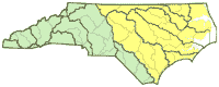 |
The National Water Quality Assessment (NAWQA) Study is an ongoing program of the U.S. Geological Survey to assess the status and trends of the Nation's streams and groundwater quality and to examine the processes that control water quality.
Science Topic:
Increased Population and Water Resources
Groundwater resources
Agriculture and Water Quality
Estuarine and Coastal Processes
Support of Federal and State Programs
|
| Albemarle Sound National Monitoring Network Pilot |
 |
A Water-Quality Monitoring Network for Albemarle Sound will be developed to examine critical water-quality management issues as a pilot study of the National Monitoring Network for U.S. Coastal Waters and their Tributaries.
Science Topic:
Increased Population and Water Resources
Groundwater resources
Agriculture and Water Quality
Estuarine and Coastal Processes
Support of Federal and State Programs
|
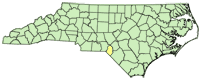
| Surface-Water Quality and Swine CAFOs |
 |
This study is designed to characterize stream water-quality conditions in Coastal Plain watersheds to document whether swine concentrated animal feeding operations (CAFOs) have a measurable effect on surface water nutrient concentrations. It will provide a scientific basis for water-resource managers and policy makers to evaluate existing, or establish new, regulations or procedures at permitted CAFOs for protecting and enhancing stream water quality in nutrient impaired waters in eastern North Carolina.
Science Topic:
Agriculture and Water Quality
Support of Federal and State Programs
|
| Mid-Currituck Bridge Water Quality |
 |
The North Carolina Department of Transportation is developing a proposal to build a 7.0-mile-long two-lane toll bridge across Currituck Sound. From 2011 to 2013, the USGS will be collecting regular water quality samples as well as bed sediment samples in the proposed bridge location to document the existing water quality conditions.
Science Topic:
Increased Population and Water Resources
Estuarine and Coastal Processes
Support of Federal and State Programs
|
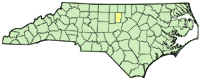
| National Trends Network (Precipitation) - Station NC36 |
 |
The National Atmospheric Deposition Program/National Trends Network (NADP/NTN) is a nationwide network of over 250 precipitation monitoring sites. The network is a cooperative effort between many different groups, including the U.S. Geological Survey, who has operated the Jordan Creek Station (NC36) in Scotland County, North Carolina since 1983.
Science Topic:
Support of Federal and State Programs
Hydrologic and Geospatial data
|
| Factors affecting nitrogen and phosphorus loads in nutrient-sensitive waters of eastern North Carolina |
 |
The primary study objectives include advancing the NC Department of Water Quality's development and implementation of management strategies for reducing nitrogen and phosphorus loadings in eastern North Carolina by 1) providing data necessary for addressing TMDL allocations and targeting watersheds where restoration efforts will be most effective, and 2) developing methods for identifying watersheds that are most likely to export nutrients (total nitrogen, total nitrate, and total phosphorus) from nonpoint-source pollution.
Science Topic:
Agriculture and Water Quality
Support of Federal and State Programs
|
| Effects of land-applied biosolids on water quality in the Jordan Lake Watershed |
 |
The practice of applying biosolids from municipal wastewater treatment plants to agricultural fields is becoming commonplace across much of the Piedmont and Coastal Plain of North Carolina. In 2009, there were 5,145 fields (107,000 acres) permitted for land application of municipal biosolids in North Carolina.
However, recent studies have shown that biosolids can pose a threat to human and environmental health. The impact of land applied municipal biosolids to agricultural fields on delivery of nutrients, bacteria, metals and emerging contaminants to surface water and groundwater resources is largely unknown. The lack of data from existing sites makes it difficult for the NC Division of Water Quality to assess how well existing regulations protect the waters of the State or to even recommend effective changes to regulations or procedures.
Science Topic:
Agriculture and Water Quality
Support of Federal and State Programs
|
| Roanoke River Water-Quality Monitoring and Modeling |
 |
The relations among river flow, floodplain water level, and instream dissolved-oxygen (DO) concentrations are important but poorly understood for the Roanoke River. Flooding and floodplain inundation no longer follow a natural seasonal pattern of flooding in the winter and occasionally in the fall, and lower flows throughout the remainder of the year, but are primarily governed by upstream reservoir releases. The timing, duration, and extent of floodplain inundation can have either positive or negative effects on the ecosystem in the lower Roanoke River corridor, depending on the inundation characteristics. Timing, depth, and duration of floodplain inundation affects habitat use and reproductive success of wildlife and regeneration of bottomland hardwood trees.
Science Topic:
Estuarine and Coastal Processes
Support of Federal and State Programs
Hydrologic and Geospatial data
|
| Accounting for Water Needs of Southeast Region National Wildlife Refuges |
 |
This project will provide spatially-explicit documentation of water quantity, timing, and distribution of water on six NWRs in the Southeast that are considered high priority due to known or potential stressors such as population growth, hydrologic manipulation, ongoing litigation, and/or recent changes in state water law.
Science Topic:
Aquatic Habitat Restoration
Support of Federal and State Programs
|
| Rating Unsaturated Zone and Watershed Characteristics of Public Water Supplies - 2009 Updates |
 |
The 1996 Amendments to the Safe Drinking Water Act require that each state prepare a source-water assessment for all public water supplies. In 1999, the U.S. Geological Survey provided components of the inherent vulnerability rating that were used with the contaminant rating to determine the overall susceptibility rating of source water supplies. In 2009, the USGS updated key layers of the unsaturated zone and watershed characteristic rating using the methodology developed for the 1999 project work.
Science Topic:
Groundwater resources
Increased Population and Water Resources
Support of Federal and State Programs
|
| Continuous water-quality monitoring at Lake Mattamuskeet |
 |
The U.S. Fish and Wildlife Service has partnered with the U.S. Geological Survey to establish two automated continuous water-quality monitoring stations at Lake Mattamuskeet to collect data useful for management of the lake. Stations on the east and west side of the lake measure water level, clarity, dissolved oxygen, pH, temperature, salinity, and conductivity.
Science Topic:
Hydrologic and Geospatial data
Support of Federal and State Programs
Aquatic Habitat Restoration
|


