| Albemarle-Pamlico NAWQA |
 |
The National Water Quality Assessment (NAWQA) Study is an ongoing program of the U.S. Geological Survey to assess the status and trends of the Nation's streams and groundwater quality and to examine the processes that control water quality.
Science Topic:
Increased Population and Water Resources
Groundwater resources
Agriculture and Water Quality
Estuarine and Coastal Processes
Support of Federal and State Programs
|
| Albemarle Sound National Monitoring Network Pilot |
 |
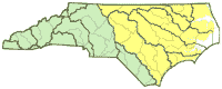
A Water-Quality Monitoring Network for Albemarle Sound will be developed to examine critical water-quality management issues as a pilot study of the National Monitoring Network for U.S. Coastal Waters and their Tributaries.
Science Topic:
Increased Population and Water Resources
Groundwater resources
Agriculture and Water Quality
Estuarine and Coastal Processes
Support of Federal and State Programs
|
| Brunswick County Groundwater-Level Monitoring |
 |
Since 2000, the population of Brunswick County has grown by more than 50%, over two times the 22% growth experienced by the State of North Carolina as a whole (U.S. Census Bureau, 2014). A growth of this magnitude places significant stress on Brunswick County's natural resources. County planners have recognized the potential consequences of land use changes associated with growth and the resulting increased demand on water resources by consolidating the many public utility providers into one organization and embarking on an aggressive utility expansion plan. In order to make informed water resource planning decisions, County officials need up-to-date water-resource information. To address concerns about the availability of groundwater in the Brunswick County area, the U.S. Geological Survey (USGS) and Brunswick County initiated a cooperative water-resources program in 1998.
Science Topic:
Increased Population and Water Resources
Groundwater resources
Hydrologic and Geospatial data
|
| Catawba-Wateree Groundwater Network |
 |
The recent multiyear drought in North and South Carolina (summer 1998-fall 2002) made critical the recognition of the vulnerability of the water resources in these two States to climatic conditions. To prepare for drought conditions in the future, water managers and State and Federal water-resource agencies are seeking tools to assess hydrologic conditions in both a predictive and responsive manner. Monitoring networks of near real-time streamflow gages (surface-water stage/discharge) and wells (groundwater levels) are essential components typically used to assess hydrologic conditions.
Science Topic:
Groundwater resources
Hydrologic and Geospatial data
|
| Moore County Groundwater-Level Monitoring |
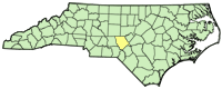 |
Moore County is part of the Sand-hills region of southeastern North Carolina within the Coastal Plain physiographic province. The County's population has increased almost 17 percent from 2000 to 2009 years to 87,000 (U.S. Census Bureau, 2009). With this growing population comes a higher demand on the water resources of the County. The increasing demand for drinking water is one of the major issues facing the Moore County area.
The principal study objective is to collect water-level data at existing monitoring wells to establish a long-term data set that can be used to monitor changes in water levels and to aid in the future management of the county's groundwater resources.
Science Topic:
Groundwater resources
|
| Hydrologic Evaluation of New Hanover County Aquifers (Phase 2) |
 |
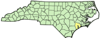
New Hanover County is one of the most populated areas along the North Carolina coastline and the population is projected to expand by 25 percent over the next 20 years. In 2005, groundwater supplied about 20 million gallons per day of potable water and comprised about 30% of the total fresh water used in the County. County managers and town planners are concerned about escalating demand for groundwater within the county and recognize the importance of high-quality drinking water to meet the demands of a growing population. This study will describe the availability and quality of groundwater in the surficial, Castle Hayne and Peedee aquifers in New Hanover County and forecast the effect on groundwater resources induced from changes in external conditions such as withdrawals, river channel deepening, sea-level rise, and aquifer storage and recovery.
Science Topic:
Increased Population and Water Resources
Groundwater resources
|
| Onslow County Region Groundwater Flow Model |
 |
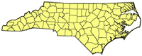
Increased development of the Castle Hayne (carbonate) aquifer has occurred in Onslow County as a result of reduced withdrawals from the Cretaceous aquifers. Increased groundwater withdrawals from these aquifers and their close proximity to the Atlantic Ocean increase the potential for movement of saltwater into the aquifers. Because the Castle Hayne aquifer is unconfined in parts of the county and is carbonate in composition, it also is susceptible to contamination from human activities on the land. The most recent comprehensive groundwater study conducted in Onslow County was completed in 1989 (Lyke and Winner, 1990); a more current tool is needed to assess the long-term effects of groundwater withdrawals on groundwater levels and saltwater movement in the area.
Science Topic:
Increased Population and Water Resources
Groundwater resources
|
| Shale Gas Baseline Groundwater Sampling Project |
 |
The U.S. Geological Survey (USGS) North Carolina Water Science Center is conducting an inventory of well records and baseline groundwater-quality sampling to better delineate areas of groundwater use and groundwater-quality characteristics prior to potential shale gas exploration in the Triassic Basins of Lee and Chatham Counties, North Carolina. Shale Gas exploration has become economically viable in many areas of the United States as a result of improved directional drilling capabilities and hydraulic fracturing ("fracking") techniques. The compilation of baseline groundwater-quality data in North Carolina is an opportunity for comparison to data collected after drilling activities commence should the State allow Shale Gas exploration to occur.
Science Topic:
Groundwater resources
|
| Rating Unsaturated Zone and Watershed Characteristics of Public Water Supplies - 2009 Updates |
 |
The 1996 Amendments to the Safe Drinking Water Act require that each state prepare a source-water assessment for all public water supplies. In 1999, the U.S. Geological Survey provided components of the inherent vulnerability rating that were used with the contaminant rating to determine the overall susceptibility rating of source water supplies. In 2009, the USGS updated key layers of the unsaturated zone and watershed characteristic rating using the methodology developed for the 1999 project work.
Science Topic:
Groundwater resources
Increased Population and Water Resources
Support of Federal and State Programs
|
| EPA GMH Electronics Superfund Site near Roxboro, NC |
 |
Operations at a former gasoline station/store and electronic component production facility may have resulted in the presence of volatile-organic compound (VOC) and dense non-aqueous-phase liquids (DNAPL) plumes in groundwater in the area. The USGS is assisting the Environmental Protection Agency with groundwater investigations near the site.
Science Topic:
Groundwater resources
|


