USGS - science for a changing world

South Atlantic Water Science Center - North Carolina Office

South Atlantic WSC Home Data Projects Publications Drought Floods Media About Us Contact [an error occurred while processing this directive]   Internal

Map of North Carolina highlighting the project study area

Project Overview

Full Title
Hydraulic Modeling for Management Application at Pee Dee National Wildlife Refuge

Location
  Anson and Richmond Counties

Cooperating Agencies
U.S. Fish and Wildlife Service

Project Chief
Doug Smith

Period of Project
2011 - 2013

Science Topic
Hydrologic and Geospatial data
Hydrologic Hazards

USGS IN YOUR STATE

USGS Water Science Centers are located in each state.

There is a USGS Water Science Center office in each State. Washington Oregon California Idaho Nevada Montana Wyoming Utah Colorado Arizona New Mexico North Dakota South Dakota Nebraska Kansas Oklahoma Texas Minnesota Iowa Missouri Arkansas Louisiana Wisconsin Illinois Mississippi Michigan Indiana Ohio Kentucky Tennessee Alabama Pennsylvania West Virginia Georgia Florida Caribbean Alaska Hawaii New York Vermont New Hampshire Maine Massachusetts South Carolina North Carolina Rhode Island Virginia Connecticut New Jersey Maryland-Delaware-D.C.

Pee Dee National Wildlife Refuge flow model

Map

Location of study area in North Carolina

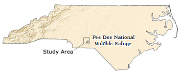
Location of study area and Pee Dee NWR in North Carolina

As part of the study, stage was continuously measured at one site on Brown Creek and two sites on the Pee Dee River. Partial records of stage were recorded for high-flow conditions at two additional sites on Brown Creek, one site on Thoroughfare Creek and one additional site on the Pee Dee River. Existing USGS streamgages on the Pee Dee River directly downstream of Lake Tillery and on the Rocky River near Norwood, NC were also utilized in the study. Data from all of these sites were used for model development and calibration.

Map
Symbol
Map
Number
Station
Number
Station Name Data type Period of Record Drainage
Area (mi2)
Latitude Longitude
Existing site 1 0212378405 Pee Dee River at NC Hwy 731 near Ansonville, NC Existing continuous stage data 3/2009 to present 4,694 35° 12' 02.4" 80° 03' 42.5"
Continuous data 2 02126375 Pee Dee River at Pee Dee Refuge near Ansonville, NC Continuous stage data 8/2011 to present 6,130 35° 06' 11.58" 80° 02' 45.36"
Partial data 3 02126395 Pee Dee River above Brown Creek near Ansonville, NC Partial-record stage data 8/2011 to 8/2013 1 6,140 35° 05' 25.92" 80° 01' 21.38"
Continuous data 4 02127500 Pee Dee River at NC Hwy 109 near Ansonville, NC Continuous stage data 11/2011 to 8/2013 6,320 35° 05' 07" 79° 59' 57"
Continuous data 5 02127318 Brown Creek at US Hwy 52 near Ansonville, NC Continuous stage data 11/2011 to 8/2013 152 35° 04' 04"  80° 05' 54"
Partial data 6 02127422 Brown Creek at Bennett Bridge near Ansonville, NC Partial-record stage data 8/2011 to 8/2013 1, 2 163 35° 03' 48.43" 80° 03' 10.61"
Partial data 7 02127461 Brown Creek at Grassy Island Road near Ansonville, NC Partial-record stage data 4/2012 to 8/2013 1 179 35° 04' 51" 80° 01' 34"
Partial data 8 02126385 Thoroughfare Creek near Ansonville, NC Partial-record stage data 8/2011 to 8/2013 1 0.57 35° 05' 36.62" 80° 02' 49.42"
Existing site 9 02126000 Rocky River near Norwood, N.C. Existing continuous stage and streamflow data 10/1929 to present 1,372 35° 08' 56" 80° 10' 33"

1 Period of record for partial-record sites indicates the dates equipment was installed and removed for this project. These stations were used to record high-flow conditions only, so there are limited recorded data points at each station. Data will be published in the final report.

2 Station 02127422, Brown Creek at Bennett Bridge near Ansonville, had been operated as a partial record station prior to this project. Periodic discharge measurements made at this site from 1985 to 1995 were used in model development and calibration.

USGS Home Water Climate Change Core Science Ecosystems Energy and Minerals Env. Health Hazards

Accessibility FOIA Privacy Policies and Notices

Take Pride in America logo USA.gov logo U.S. Department of the Interior | U.S. Geological Survey
URL: https://nc.water.usgs.gov/projects/peedee_model/map.html
Page Contact Information: North Carolina Web Development Team
Page Last Modified: Monday, 05-Dec-2016 11:04:59 EST