
South Atlantic Water Science Center
South Atlantic Water Science Center
![]()
Full Title
Wake County Groundwater Network
Location
![]() Northern Wake County, NC
Northern Wake County, NC
Partner Agencies
Partner Agencies
Project Chief
Melinda Chapman
mjchap@usgs.gov
Period of Project
October 2009 - current
Team Members
Scott Caldwell
Science Topics
Hydrologic and Geospatial data
Hydrologic Hazards
Increased Population and Water Resources
Groundwater resources
This project was completed in 2012. These pages are for historical purposes only.
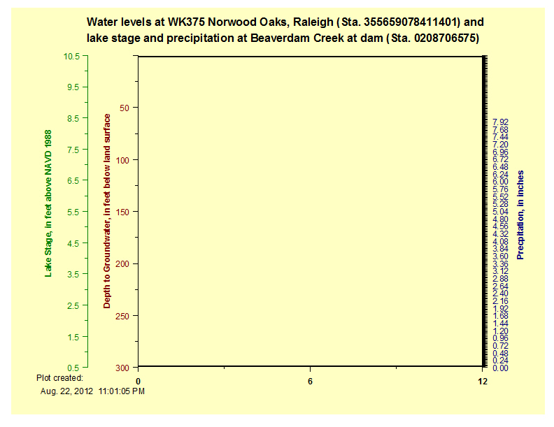
WK-375 Norwood Oaks, Raleigh, NC Site ID: 355635078385101Latitude: 35°56'59" Longitude: 78°41'13" Real-time data Station information WK-394 Norwood Oaks, Raleigh, NC Site ID: 355641078410101Latitude: 35°56'40" Longitude: 78°41'00" Real-time data Station information WK-284 Lake Wheeler, Raleigh, NC Site ID: 354404078403101Latitude: 35°44'04" Longitude: 78°40'31" Real-time data Station information
Beaverdam Creek near Creedmoor, NC Site ID: 0208706575Latitude: 36°01'25" Longitude: 78°41'21" Real-time data Station Information
Falls Lake above dam near Falls, NC Site ID: 02087182Latitude: 35°56'28" Longitude: 78°35'00" Real-time data Station Information |
|
|
Combined Groundwater, Precipitation, and Lake Level graph for the Falls Lake area, Oct 2009-present. |
|
|

 Precipitation
 Lake Level