|
Project Overview
Full Title
Investigation of effects of land-use and land-use change on water-quality of small streams in the Treyburn Development of the Falls Lake Watershed
Location
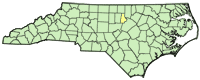
 Treyburn Development in Durham County Treyburn Development in Durham County
Cooperating Agencies
City of Durham
Project Chief
Jason M. Fine
jmfine@usgs.gov
Period of Project
1988-present
Science Topic:
Increased Population and Water Resources
USGS IN YOUR STATE
USGS Water Science Centers are located in each state.

|
Effects of land-use change on water-quality in the Treyburn Development of the Falls Lake Watershed
This project was completed in 2013. These pages are for historical purposes only.
Study Area
Maps and table are Figure 1, Figure 2, and Table 1 from WRIR 02-4046: Water-quality and physical characteristics of streams in the Treyburn development area of Falls Lake watershed, North Carolina, 1994-98.
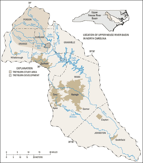
Figure 1. Location of the Treyburn development and study area in the Falls Lake watershed, North Carolina.
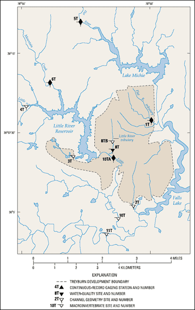
Figure 2. Locations of study sites in the Treyburn development area of North Carolina.
Table 1. Data-collection sites in the Treyburn development study area, North Carolina
[USGS, U.S. Geological Survey; mi2, square mile; S, streamflow; Q, water quality; C, stream channel characteristics; M, macroinvertebrates; SR, secondary
road; —, no data]
| Site no. (fig. 2) |
USGS station numbera |
Site name |
Drainage area (mi2) |
Type of data collected |
Land cover |
Period of record |
| Continuous streamflow record |
Water quality |
| 1T |
0208650112 |
Flat River tributary near
Willardville |
1.14 |
S, Q, C, M |
Forest |
3/88-9/90,
10/94-present |
1988-91,
1994-present |
| 2T |
0208527100 |
Eno River tributary at SR 1004
near Fairntosh |
.57 |
C, M |
Industrial |
— |
— |
| 3T |
0208524170 |
Little River tributary near Durham |
1.02 |
C, M |
Forest and residential |
— |
2/88-4/94 |
| 4T |
0208521324 |
Little River at SR 1461 near
Orange Factory |
78.2 |
C, M |
Forest and agricultural |
10/87-present |
10/87-present |
| 5T |
02085500 |
Flat River at Bahama |
149 |
S, Q, C, M |
Mixed forest and
agricultural |
7/25-present |
1988-93,
1994-present |
| 6T |
0208524090 |
Mountain Creek at SR 1617 near
Bahama |
8.00 |
S, Q, C, M |
Mixed forest,
agricultural, and
residential |
10/94-present |
1988-91,
1994-present |
| 8T |
0208524950 |
Little River tributary at Fairntosh |
.86 |
Sb, Q, C, M |
Golf course and
residential |
—b |
1994-present |
| 8TB |
0208524930 |
Little River tributary 0.3 mile
above the mouth at Fairntosh |
.60 |
M |
Golf course and
residential |
— |
2/88-4/94 |
| 10T |
02085262 |
Little River near Weaver |
104 |
M |
Mixed forest,
agricultural, and
residential |
— |
1988 |
| 10TA |
0208524975 |
Little River below Little River
tributary at Fairntosh |
99.0 |
S, Q, C |
Mixed forest,
agricultural, and
residential/reservoir
outfall |
10/95-present |
1995-present |
| 11T |
02085079 |
Eno River near Weaver |
148 |
M |
Mixed forest and
residential |
— |
11/82-8/99 |
a Station number is assigned by the U.S. Geological Survey on the basis of geographic location. The downstream order number system is used for
surface-water sites.
b Streamflow was measured only when a water-quality sample was collected.
|

