|
Project Overview
Full Title
Piedmont-Mountains Groundwater
Location
 Iredell, Wake, Rockingham, Buncombe, Macon, Randolph, Orange and Watauga counties Iredell, Wake, Rockingham, Buncombe, Macon, Randolph, Orange and Watauga counties
Cooperating Agencies
North Carolina Department of Environmental and Natural Resources Division of Water Quality Aquifer Protection Section
Project Chief
Melinda Chapman
mjchap@usgs.gov
Period of Project
1999-2011
Team Members
Brad Huffman
Kristen McSwain
Steve Harden
USGS IN YOUR STATE
USGS Water Science Centers are located in each state.

|
Piedmont-Mountains Groundwater
This project was completed in 2012. These pages are for historical purposes only.
Study Area and Data
Figure 1. Locations of research stations selected for investigations as part of the cooperative U.S. Geological Survey and North Carolina Division of Water Quality Piedmont-Mountains Resource Evaluation Program in North Carolina.
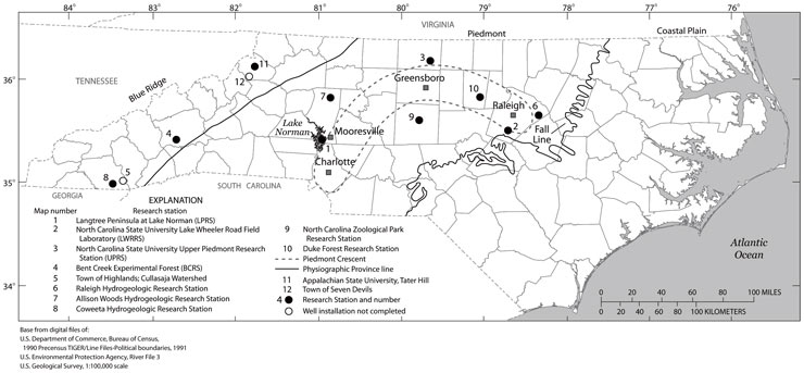
| Map# |
Study Site |
County |
DENR Region |
| 1 |
Langtree Peninsula at Lake Norman |
Iredell |
Mooresville |
| |
|
| 2 |
North Carolina State University (NCSU) Lake Wheeler Road Field Laboratory |
Wake |
Raleigh |
| |
Ground-Water levels |
| WK-284 |
354404078403101 |
LAKE WHEELER RS MW-3S |
(Regolith well) |
|
| 3 |
NCSU Upper Piedmont Research Station |
Rockingham |
Winston-Salem |
| |
Ground-Water levels |
| RK-239 |
362231079410801 |
UPPER PIEDMONT RS MW-S3S |
(Regolith well) |
|
| 4 |
Bent Creek Demonstration Forest |
Buncombe |
Asheville |
| |
Ground-Water levels |
| BU-083 |
352827082383901 |
BENT CREEK RS MW-7S |
(Regolith well) |
Streamflow |
| |
03447894 |
BENT CR AT BENT CR GAP RD NR GLEN BALD, NC |
|
|
| 5 |
Town of Highlands; Cullasaja Watershed |
Macon |
Ashevillle |
| 6 |
Raleigh Hydrogeologic Research Station |
Wake |
Raleigh |
| |
Ground-Water levels |
| WK-332 |
354315078300101 |
RALEIGH RS WC-2S NR GARNER, NC |
(Regolith well) |
|
| 7 |
Allison Woods Hydrogeologic Research Station |
Iredell |
Mooresville |
| |
Ground-Water levels and
quality |
| IR-165 |
355428080493001 |
ALLISON WOODS MW-2S |
(Regolith well) |
|
| 8 |
Coweeta Hydrogeologic Research Station |
Macon |
Asheville |
| 9 |
North Carolina Zoological Park Research Station |
Randolph |
Winston-Salem |
| |
|
| 10 |
Duke Forest Research Station |
Orange |
Raleigh |
| 11 |
Tater Hill Station |
Watauga |
Winston-Salem |
| |
|
|

