|
Project Overview
Full Title
Assessing microbial contamination in the Newfound Creek watershed
Location
 Newfound Creek is a tributary to the French Broad River northwest of Asheville. Newfound Creek is a tributary to the French Broad River northwest of Asheville.
Cooperating Agencies
Buncombe County Soil and Water Conservation District
Project Chief
Elise Giddings
Period of Project
2000-2003
Team Members
Callie Oblinger
WWW Resources
UNC Asheville VWIN Program
Department of Environmental and Natural Resources: French Broad River Basinwide Water Quality Plan
Clean Water Action Plan
USGS IN YOUR STATE
USGS Water Science Centers are located in each state.

|
Newfound Creek Water Quality
This project was completed in 2003. These pages are for historical purposes only.
Study Area
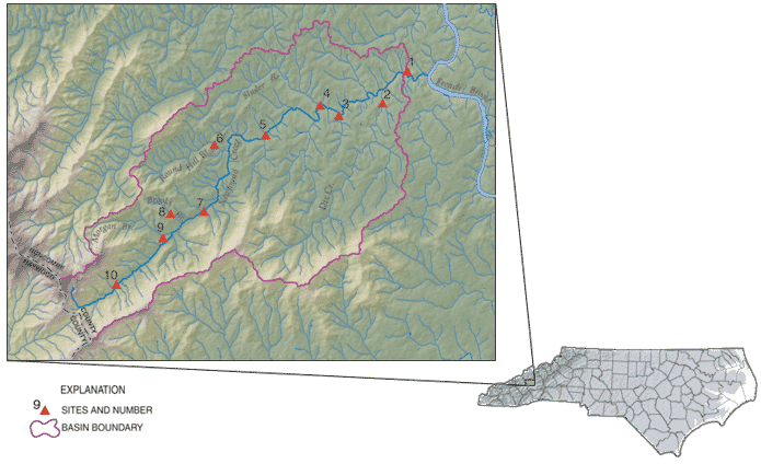
Figure 1. Location of study sites (site numbers are in table 1).
Table 1. Collection sites and types of samples collected in Newfound Creek, N.C., May 2003.
| Site |
USGS Station ID |
Site Location |
Latitude |
Longitude |
Sample Collected |
| Water |
Sediment |
| E. coli |
Fecal |
Serotype |
E. coli |
| 1 |
03451690 |
Newfound Creek at Jenkins Valley Rd. |
353958.4 |
823803.3 |
x |
x |
|
x |
| 2 |
0345168045 |
Dix Creek at Old NC20 |
353916.2 |
823839.3 |
x |
|
x |
|
| 3 |
03451662 |
Newfound Creek at Sluder Branch Rd. |
353858.5 |
823946.2 |
x |
|
|
x |
| 4 |
03451661 |
Sluder Branch at mouth |
353910.6 |
824015.9 |
x |
|
x |
|
| 5 |
03451658 |
Newfound Creek at Old Newfound Rd. |
353830.2 |
824138.5 |
x |
x |
x |
x |
| 6 |
0345165645 |
Round Hill Branch at Rabbit Ham Rd. |
353815.5 |
824257.4 |
x |
x |
x |
|
| 7 |
03451656 |
Newfound Creek at Browntown Rd. |
353650.7 |
824309.4 |
x |
x |
x |
x |
| 8 |
0345165593 |
Brooks Branch above mouth |
353646.2 |
824401.4 |
x |
|
|
|
| 9 |
0345165570 |
Morgan Branch at Morgan Branch Rd. |
353615.2 |
824411.4 |
x |
|
|
|
| 10 |
0345165540 |
Newfound Creek at Haylandy Drive |
353513.9 |
824520.8 |
x |
x |
|
x |
|

