|
Project Overview
Full Title
Real-time Flood Inundation Mapping in the Tar River Basin
Location
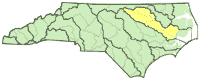
 Tar River Basin Tar River Basin
Cooperating Agencies
See below
Project Chief
Jerad Bales
Period of Project
2002-2004
WWW Resources
NC Flood Maps
USGS IN YOUR STATE
USGS Water Science Centers are located in each state.

|
Flood Inundation Mapping
This project was completed in 2004. These pages are for historical purposes only.
Study Area Map

| Map Number |
USGS Site ID |
Station Name |
| 1 |
02081500 |
Tar River near Tar River, NC |
| 2 |
02081747 |
Tar R at US 401 at Louisburg, NC |
| 3 |
02082506 |
Tar R bl Tar R Reservoir nr Rocky Mount, NC |
| 4 |
0208250885 |
Tar River at US 301 Bypass at Rocky Mount, NC |
| 5 |
02082576 |
Stony Creek near Rocky Mount, NC |
| 6 |
02082585 |
Tar River at NC 97 at Rocky Mount, NC |
| 7 |
02082770 |
Swift Creek at Hilliardston, NC |
| 8 |
0208281175 |
Swift Creek at NC 97 near Leggett, NC |
| 9 |
02082950 |
Little Fishing Creek near White Oak, NC |
| 10 |
02083000 |
Fishing Creek near Enfield, NC |
| 11 |
0208331077 |
Fishing Creek at NC 97 near Leggett, NC |
| 12 |
02083500 |
Tar River at Tarboro, NC |
| 13 |
02083640 |
Town Creek at US 258 near Pinetops, NC |
| 15 |
02083893 |
Tar River at US 264 Bypass nr Rock Springs, NC |
| 16 |
02084000 |
Tar River at Greenville, NC |
| 17 |
02084160 |
Chicod Cr at SR1760 near Simpson, NC |
| 18 |
02084173 |
Tar River at SR1565 near Grimesland, NC |
| 19 |
0208436195 |
Tranters Creek at SR1567 near Washington, NC |
|

