|
Project Overview
Full Title
Real-time Flood Inundation Mapping in the Tar River Basin
Location
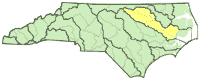
 Tar River Basin Tar River Basin
Cooperating Agencies
See below
Project Chief
Jerad Bales
Period of Project
2002-2004
WWW Resources
NC Flood Maps
USGS IN YOUR STATE
USGS Water Science Centers are located in each state.

|
Flood Inundation Mapping
This project was completed in 2004. These pages are for historical purposes only.
Introduction
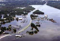
Edgecombe County, N.C., September 19, 1999—Aerial photo of severe flooding engulfing populated areas as a result of Hurricane Floyd. Picture by David Saville/FEMA News Photo.
North Carolina is subject to flooding from land-falling hurricanes, storm surge, intense thunderstorms, and slow-moving frontal systems. The existing flood information and flood forecasting system has served the State of North Carolina and the Nation well. However, as indicated by experiences during Hurricanes Fran and Floyd, as well as other flood events across the State and Nation, there is a growing demand and need for more and better flood information and flood forecasting. In 1999, Governor Hunt and the North Carolina General Assembly tasked the North Carolina Floodplain Mapping Program to improve the flood information and flood-forecasting system. Following a 2 - year period of program planning and negotiations, a multiagency group was formed to develop the flood-information and flood-forecasting system (see list of cooperative agencies). The primary U.S. Geological Survey (USGS) role in this project is to develop and implement a real-time flood information and inundation mapping component for the flood-information and flood-forecasting system.
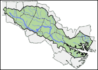
Click on map of study area to see USGS gaging station locations
|

