Soil and Water Balance model
Recharge estimation is a primary component of the water budget and provides an upper limit of measure to much of the water entering the groundwater system. The USGS will estimate natural recharge using a Soil-Water-Balance (SWB) model (Westenbroek and others, 2010). The model compiles climatological data and soil and landscape properties to create a water budget of the hydrologic system.
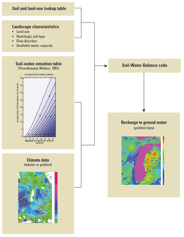
Westenbroek, S.M.; Kelson, V.A.; Dripps, W.R.; Hunt, R.J.; and Bradbury, K.R.; 2010; SWB—A modified Thornthwaite-Mather Soil-Water-Balance code for estimating groundwater recharge: U.S. Geological Survey Techniques and Methods 6–A31, 60 p.
Land/Water Demand Forecast Models
Future water demand is related to growing populations, expanding cities and changing climate and directly influence groundwater withdrawals in Wake County. This task will include the analysis of alternative futures of continued urbanization and estimate the associated development-related water demand (a combination of public supply, domestic self-supply and industrial self-supply) across the county. We will integrate site-specific long-term development plans and additional land conservation measures to refine an existing land-use and water-demand modeling framework by Sanchez and others (2018) and project urbanization and water demand to 2070.
Regional groundwater flow via MODFLOW
A Modular Three-Dimensional Finite-Difference Groundwater Flow Model (MODFLOW) (Harbaugh, 2005) will be created to assist in managing the resources of Wake County. This three-dimensional finite-difference model will simulate the water movement throughout the fractured-rock aquifer to give a better understanding of the groundwater flow throughout the County. The model will simulate water levels and groundwater withdrawals over the past 20 years to predict results of future stresses on the groundwater system.