Project Summary
Background
In 1995 Tropical Storm Jerry brought up to 9.37 inches of rain over the City of Charlotte and Mecklenburg County. The resulting floodwaters resulted in an estimated $4 million in property damage. Less than 2 years later the remnants of Hurricane Danny brought in excess of 13 inches of rain over the area resulting in yet again widespread flooding. Property damages from this event were estimated at over $60 million and three lives were lost in the floodwaters.
By 1997, the Charlotte-Mecklenburg hydrologic network, maintained and operated by the USGS, consisted of 16 streamgages and 40 raingages. The network was equipped with landline telemetry, which proved reliable for data collection, but was not effective for rapid dissemination of the data to facilitate flood warning. The recent floods had exposed this vulnerability and the search for a solution began in earnest. The challenge was to develop a system that could provide real time data for emergency managers and quality assured time series data for post event analysis. The recent floods also showed the need for more streamgages in critical watersheds, and more raingages throughout the area.
The transformation began in October 1998 using a combination of UHF radios, two-way polling, ALERT, and GOES satellite transmitters. Redundancy and backup were built into every aspect of the network to increase reliability. Network growth and enhancements are ongoing.
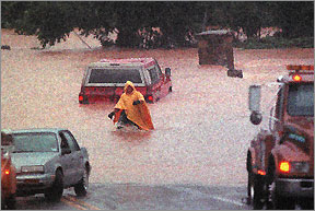
A tow truck driver wades through waist-deep water to assist motorists as Stewart Creek overtops Morehead Street. (From FS 036-98; Photograph from The Charlotte Observer/Kent D. Johnson)
Today
Currently, all sites within the network record 5-minute interval data. Sites that use dual-channel UHF radios, transmit the data using a unique one-way data polling system that allows over 100 sites to send the data to the base station computer within minutes of each 5-minute interval. These data are quickly processed and loaded in the National Water Information System (NWIS). Some sites use satellite telemetry to transmit the data hourly but when certain gage-height or rainfall thresholds are met, can transmit more frequently. In addition, 5 streamgage locations have Web cameras installed. These data are used by scientists, engineers, and managers to detect potential problems resulting from intense rain storms, determine flood-prone areas, determine long-term trends, and aid in the design of bridges and culverts.
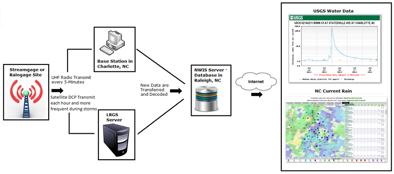
In addition to the routine polling of the data, during storm events, sites that are equipped with ALERT transmitters will immediately report the data which is captured and assessed as part of the Flood Information and Notification System (FINS). These data, which are stored and disseminated as part of the FINS network are used to provide advanced notification of possible flooding conditions to the National Weather Service and local emergency personnel, thereby enabling a faster response and possible mitigation of flood-related problems. Since the ALERT data is disseminated instantaneously as sites exceed site-specific thresholds, these data are variable interval data and typically are more susceptible to errors in data transfer. Therefore, the polled data being stored in the USGS database systems are more reliable and should be used for all post-event analysis.