The Flood Information and Notification System (FINS) Network in Charlotte and Mecklenburg County consists of 52 streamgages and 72 raingages (December 2021). Most sites in the network are equipped with radio telemetry which log and transmit data in 5-minute intervals. Some sites outside of the City of Charlotte boundary are equipped with satellite telemetry that transmit 5-minute data, hourly, and more frequently during an event. In addition, during storm events, immediate reporting of data occurs as extreme conditions or thresholds are exceeded at a given site. Under these conditions stream level and rainfall data are transmitted instantly to emergency managers and the USGS for assessment. These site-specific thresholds are used for tracking extreme hydrologic conditions during both floods and droughts.
This data-collection network is cooperatively supported by Charlotte-Mecklenburg Stormwater Services and the U.S. Geological Survey Cooperative Water Program and was developed in response to the floods of August 1995 and July 1997 (Effects of August 1995 and July 1997 Storms in the City of Charlotte and Mecklenburg County, North Carolina, FS-036-98). The network has been expanded over the last 30 years and evolved from a landline and satellite telemetry system to a true real-time system using line-of-site radios and ALERT (Automated Local Evaluation in Real Time) protocol, resulting in a robust network with built-in redundancy.
By design, the ALERT data are non-continuous and irregular because they are event driven and time-stamped when they are received by each base station. Raingage and streamflow gaging sites do not transmit ALERT data unless a site-specific threshold has been met. The regular 5-minute interval data that is received in tandem with the ALERT data are generally available online within 10 or 15 minutes after they are logged. These data are loaded into the USGS National Water Information System (NWIS) database and subsequently available on the USGS Current Water Data for North Carolina web site. Because conditions can change very rapidly in this region, having the real-time ALERT data provides immediate notification when gage-heights have increased and a certain amount of rainfall has occurred. Although, the NWIS data should always be used in lieu of the ALERT data set when it becomes available. Having both systems in place provides quick and immediate response as well as a long-term continuous dataset for historical analysis.
The data collected at these sites are used by scientists, engineers, and managers to detect potential problems with water-quality and quantity, determine flood-prone areas, determine long-term trends, and aid in the design of bridges and culverts. These data also can be used to provide advanced notification of possible flooding conditions to the National Weather Service and local emergency personnel, thereby enabling a faster response and possible mitigation of flood-related problems.
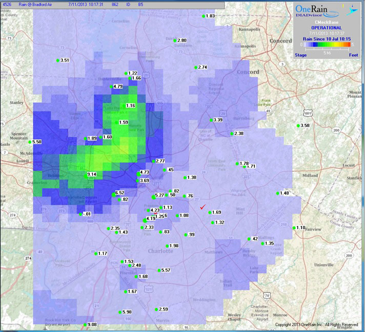
Display of ALERT data taken from a DIADvisor Base Station of a storm in July, 2013 displaying real-time stream level values with corresponding rainfall overlay.
FINS BACKGROUND AND EVOLUTION
In 1995 Tropical Storm Jerry brought up to 9.37 inches of rain over the City of Charlotte and Mecklenburg County. The resulting floodwaters resulted in an estimated $4 million in property damage. Less than 2 years later the remnants of Hurricane Danny brought in excess of 13 inches of rain over the area resulting in yet again widespread flooding. Property damages from this event were estimated at over $60 million and three lives were lost in the floodwaters.
Following the floods of 1997, Charlotte-Mecklenburg Stormwater Services, in cooperation with the U.S. Geological Survey (USGS), and with technical assistance from Campbell Scientific, OneRain (known then as DIAD), and Distinctive Automated Flood Warning Designs, embarked on an ambitious endeavor to upgrade its hydrologic data monitoring system. The goal was to develop a network that would provide real-time data to multiple users for various purposes and to enhance flood mitigation efforts. The result is a network of monitoring gages known as the Flood Information and Notification System (FINS).
In 1997, the Charlotte Mecklenburg hydrologic data collection network, maintained and operated by the USGS, consisted of 16 streamgages and 40 raingages. The network was equipped with landline telemetry, which proved reliable for data collection, but was not effective for rapid dissemination of the data to facilitate flood warning. The recent floods had exposed this vulnerability and the search for a solution began in earnest. The challenge was to develop a system that could provide real time data for emergency managers and quality assured time series data for post event analysis. The recent floods also showed the need for more streamgages in critical watersheds, and more raingages throughout the area.
The transformation began in October 1998 using a combination of UHF line-of-site radios, two-way polling, ALERT, and GOES satellite transmitters. Redundancy and backup were built into every aspect of the network to increase reliability. Additions to the network and enhancements to its operation continue to evolve as changes to the hardware and software occur. Most sites in the network are equipped with radio telemetry that transmit 5-minute interval data within minutes after each interval. Some sites are equipped with satellite telemetry that transmit 5-minute data hourly. During storm events, immediate reporting of data occurs as extreme conditions or thresholds are exceeded at a given site.
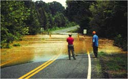
Rising floodwaters overtopping a local bridge. Photograph by Jerald B. Robinson, USGS.