USGS - science for a changing world

South Atlantic Water Science Center - North Carolina Office

South Atlantic WSC Home Data Projects Publications Drought Floods Media About Us Contact [an error occurred while processing this directive]   Internal

Map of North Carolina highlighting the project study area

Project Overview

Full Title
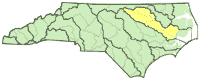
Real-time Flood Inundation Mapping in the Tar River Basin

Location
Tar River Basin

Cooperating Agencies
See below

Project Chief
Jerad Bales

Period of Project
2002-2004

WWW Resources

NC Flood Maps

USGS IN YOUR STATE

USGS Water Science Centers are located in each state.

There is a USGS Water Science Center office in each State. Washington Oregon California Idaho Nevada Montana Wyoming Utah Colorado Arizona New Mexico North Dakota South Dakota Nebraska Kansas Oklahoma Texas Minnesota Iowa Missouri Arkansas Louisiana Wisconsin Illinois Mississippi Michigan Indiana Ohio Kentucky Tennessee Alabama Pennsylvania West Virginia Georgia Florida Caribbean Alaska Hawaii New York Vermont New Hampshire Maine Massachusetts South Carolina North Carolina Rhode Island Virginia Connecticut New Jersey Maryland-Delaware-D.C.

Flood Inundation Mapping

This project was completed in 2004. These pages are for historical purposes only.

Cooperating Agencies

Cooperating Agencies

Federal Agencies
FEMA - Federal Emergency Management Agency: Flood Hazard Mapping
NWS - National Weather Service
State Agencies
NCDEM - N.C. Division of Emergency Management
NCCGIA - Center for Geographic Information and Analysis
NCFMP - N.C. Floodplain Mapping Program

USGS Home Water Climate Change Core Science Ecosystems Energy and Minerals Env. Health Hazards

Accessibility FOIA Privacy Policies and Notices

Take Pride in America logo USA.gov logo U.S. Department of the Interior | U.S. Geological Survey
URL: https://nc.water.usgs.gov/projects/finmap/coop.html
Page Contact Information: North Carolina Web Development Team
Page Last Modified: Monday, 05-Dec-2016 11:04:29 EST