|
Project Overview
Full Title
Currituck Sound Water Quality Monitoring
Location
 Currituck County, Dare County, City of Chesapeake, VA, and City of Virginia Beach, VA Currituck County, Dare County, City of Chesapeake, VA, and City of Virginia Beach, VA
Cooperating Agencies
NC Division of Water Resources
US Army Corps of Engineers
Elizabeth City State University
US Fish and Wildlife Service
The North Carolina National Estuarine Research Reserve
Project Chief
Jason Fine
[email protected]
Period of Project
2005 to present
USGS IN YOUR STATE
USGS Water Science Centers are located in each state.

|
Currituck Sound
This project was completed in 2012. These pages are for historical purposes only.
Study Area and Data
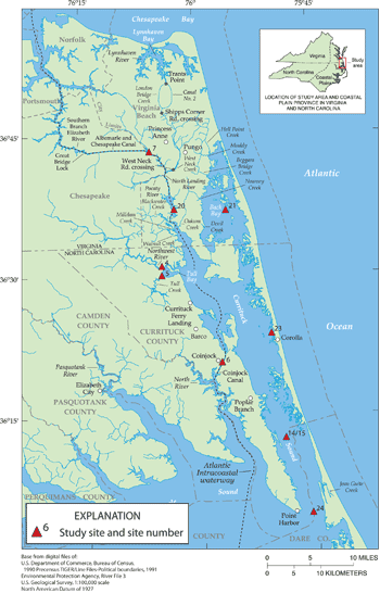
Map of Study Area, Currituck Sound, NC (click map to enlarge)
| CONTINUOUS WATER QUALITY DATA with streamflow data * |
| [g, gage height; v, velocity; d, discharge; t, temperature; s, salinity; do, dissolved oxygen; p, pH; tu, turbidity; c, chlorophyll] |
Station Number |
Location |
Site No. |
Collecting Agency |
Data Available |
Period of Record |
Data File |
02043410 |
Northwest River Near Moyock, NC |
4 |
ECSU |
g, v, d, t, s, do, p, tu, c |
March 2006 to June 2007 |
|
02043415 |
Tull Creek Near Currituck, NC |
5 |
ECSU |
g, v, d, t, s, do, p, tu, c |
April 2006 to June 2007 |
|
0204343500 |
Intercoastal Waterway near Coinjock, NC |
6 |
ECSU |
g, v, d, t, s, do, p, tu, c |
March 2006 to June 2007 |
|
02043460 |
Currituck Sound off Dews Island near Jarvisburg, NC |
14/15 |
ECSU |
t, s, do, p, tu, c |
April 2006 to June 2007 |
|
02043270 |
North Landing River near Creeds, VA |
20 |
ECSU |
g, v, d, t, s, do, p, tu, c |
March 2006 to June 2007 |
|
02043016 |
Back Bay below Ragged Island, VA |
21 |
US FWS |
t, s, do, p, tu |
March 2006 to July 2007 |
|
02043430 |
Upper Currituck Sound near Corolla, NC |
23 |
NC NEER |
t, s, do, p, tu |
April 2006 to July 2007 |
|
0204347500 |
Currituck Sound near Point Harbor, NC |
24 |
NC NEER |
g, v, t, s, do, p, tu |
March 2006 to July 2007 |
|
| DISCRETE WATER-QUALITY DATA (2006-007_WQ_Data.xls) |
* Streamflow data was collected by the USGS. For all streamflow data for the project and expanded site information, please refer to NWIS Web.
|

