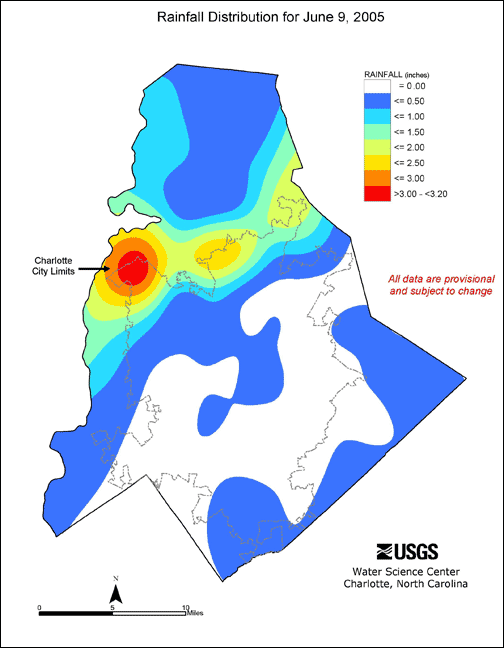
| Station ID | CRN | Location | Precipitation Total (inches) |
|---|---|---|---|
| 351812080445545 | CRN01 | Ken Hoffman (Fire Station 27) | 0.00 |
| 351954080493445 | CRN02 | Old Statesville Road (Fire Station 28) | 2.10 |
| 0214620760 | CRN03 | Starita Road | 0.05 |
| 351132080562345 | CRN04 | Belle Oaks (Fire Station 30) | 0.01 |
| 351642080533445 | CRN05 | CMUD Office | 0.15 |
| 02146750 | CRN06 | McAlpine Creek below McMullen Creek | 0.00 |
| 350351080454145 | CRN07 | McKee Rd (Fire Station 9) | 0.01 |
| 350314080484945 | CRN08 | St. Matthews Church | 0.08 |
| 351414080463245 | CRN09 | Frontenac Road (Fire Station 15) | 0.00 |
| 02146600 | CRN10 | McAlpine Creek at Sardis Road | 0.00 |
| 351331080525945 | CRN11 | Remount Road (Fire Station 10) | 0.02 |
| 350823080505345 | CRN12 | Park South Drive (Fire Station 16) | 0.00 |
| 350947080524945 | CRN13 | USGS Office | 0.00 |
| 351553080562645 | CRN14 | Little Rock Road (Fire Station 21) | 1.14 |
| 351320080502645 | CRN15 | Charlotte Mecklenburg Government Center | 0.00 |
| 351540080430045 | CRN16 | Reed Creek Park | 0.00 |
| 351023080435745 | CRN17 | Piney Grove Elementary | 0.00 |
| 02142900 | CRN18 | Long Creek near Paw Creek | 1.83 |
| 351132080504145 | CRN19 | Freedom Park | 0.00 |
| 351032080475245 | CRN20 | Sharon Amity Road (Fire Station 14) | 0.00 |
| 350842080572801 | CRN21 | Kennedy Junior High School | 0.00 |
| 350623080583801 | CRN22 | Lake Wylie Elementary School | 0.00 |
| 351302080412701 | CRN23 | Harrisburg Landfill | 0.00 |
| 02142651 | CRN24 | Westmoreland Road | 0.24 |
| 0214266075 | CRN25 | McCoy Road | 0.30 |
| 352432080473745 | CRN26 | Bradford Airfield | 1.08 |
| 351604080470845 | CRN27 | Hidden Valley Elementary | 0.00 |
| 0214635212 | CRN28 | Crompton Street | 0.00 |
| 351218080331345 | CRN29 | Clear Creek Boy Scout Camp | 0.02 |
| 351455080374445 | CRN30 | Rhyne Farm | 0.01 |
| 350110080502045 | CRN31 | Elon Homes | 0.03 |
| 351028080385545 | CRN32 | Bain Elementary School | 0.00 |
| 352000080414645 | CRN33 | Mallard Creek WWTP | 0.00 |
| 352555080574445 | CRN34 | Cowans Ford Dam | 0.99 |
| 0214267600 | CRN35 | Mountain Island Dam | 2.27 |
| 352921080473245 | CRN36 | West Fork Substation | 0.14 |
| 351247080592745 | CRN37 | Berryhill Elementary School | 0.80 |
| 350200081020345 | CRN38 | Tega Cay Town Hall, S.C. | 0.00 |
| 350634080405245 | CRN39 | Phillips Farm | 0.13 |
| 353003080591745 | CRN40 | Westport Golf Course | 0.25 |
| 0214266000 | CRN41 | McDowell Creek | 0.52 |
| 353014080524945 | CRN42 | Norman Shores Development | 0.21 |
| 352440080505045 | CRN43 | Huntersville Elementary School | 0.24 |
| 352718080484345 | CRN44 | Knox Farm | 0.15 |
| 350903081004545 | CRN45 | Withers Cove | 0.30 |
| 352135080462045 | CRN46 | Oehler Farm | 1.67 |
| 351229080460245 | CRN47 | Winterfield Elementary | 0.00 |
| 350637080475645 | CRN48 | Olde Providence Elementary | 0.00 |
| 352224080500345 | CRN49 | North Mecklenburg High School | 0.39 |
| 351501080512145 | CRN50 | Vest Treatment Plant | 0.29 |
| 352310080424845 | CRN51 | Concord Airport | 0.76 |
| 351753081011745 | CRN52 | Ida Rankin Elementary | 1.32 |
| 351412080541245 | CRN53 | Harding High School | 0.05 |
| 351741080475045 | CRN54 | Derita Elementary | 0.02 |
| 350324080551845 | CRN55 | Hammond Farm | 0.00 |
| 350635080513245 | CRN56 | South Mecklenburg High School | 0.00 |
| 351109080412145 | CRN57 | Lebanon Road Elementary School | 0.00 |
| 352007080463145 | CRN58 | Mallard Creek Elementary | 0.80 |
| 350624081023345 | CRN59 | Camp Thunderbird, S.C. | 0.20 |
| 351104080521845 | CRN60 | Collinswood Elementary School | 0.00 |
| 351816080564345 | CRN61 | Coulwood Middle School | 3.19 |
| 352523080535545 | CRN62 | Cooke Farm | 0.57 |
| 352622080434145 | CRN63 | Odell Elementary School | 1.67 |
| 351928080515645 | CRN64 | Hornets Nest Elementary | 2.38 |
| 351536080410645 | CRN65 | Reedy Creek Elementary | 0.05 |
| 351229080480145 | CRN66 | Chantilly Elementary School | 0.09 |
| 350856080383445 | CRN67 | Thompson Farm | 0.00 |
| 351145080371945 | CRN68 | White Farm | 0.16 |
| 350646080432545 | CRN69 | Matthews Elementary School | 0.00 |
| 350630080455845 | CRN70 | Providence High School | 0.00 |
--- indicates data are not available